

This post was originally published on this site.
Met Office weather warnings – including a more severe amber warning – have been issued for rain in parts of the UK.
Heavy rain in eastern Scotland, Northern Ireland and parts of England and Wales will bring significant rainfall totals and the risk of flooding.
Strong winds will accompany the rain, particularly in north-east Scotland.
Into Friday, Storm Ingrid – named by the Portuguese weather service – will bring rain and strong winds into south-western areas of England and Wales with further warnings issued here.
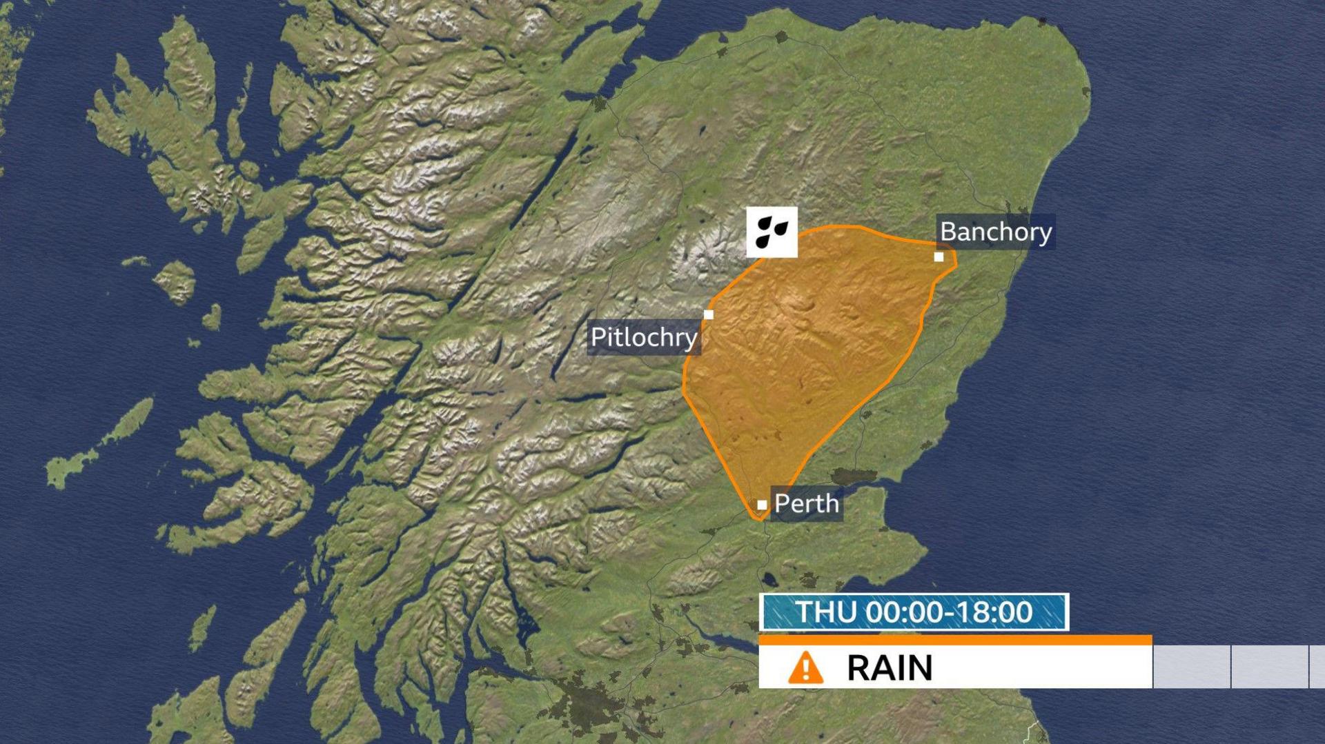
Heavy rain and strong winds have continued in eastern Scotland, where there is a Met Office amber warning in force for Grampian, Angus, and Perth and Kinross until 18:00 GMT.
Rainfall accumulations of 60-80mm are likely, with as much as 100-120mm over high ground.
Totals since Wednesday evening may exceed 150 mm in a few places. This is expected to lead to some surface water and river flooding across the area.
There is also a wider yellow warning across the rest of eastern Scotland where rainfall accumulations of 30-60mm will be seen widely.
The Met Office warns that with the ground already saturated from recent rain and and snow thaw, this may lead to some flooding in places.
A strong south-easterly wind in north-east Scotland will also make it feel particularly unpleasant.
Additional yellow warnings are in force on Thursday across south-east Wales, Somerset and Devon from 08:00 to 16:00 and Northern Ireland from 10:00 to 23:59.
Persistent and heavy rain in these areas through the day falling on saturated ground could lead to some flooding and transport disruption.
On Thursday morning there were nearly 160 flood warnings in force across England, Scotland and Wales.
Elsewhere, the weather remains generally cloudy and breezy, with rain and drizzle.
On Friday, the UK will be impacted by Storm Ingrid, which was named by the Portuguese weather service due to the impacts expected there from strong winds and heavy rain.
The centre of Ingrid will move close to the south-west of England and north-west France.
Winds in the UK will strengthen on Friday, with gusts up to 60mph expected in south-west England and Wales along with further heavy rain at times.
A Met Office yellow warning will come into force here from 02:00 GMT Friday to 09:00 Saturday.
While the winds won’t be as powerful or dangerous as the near 100mph winds experienced in south-west England during Storm Goretti, there could still be some impacts.
With saturated ground, flooding is possible and, with coastal gales, there will be large overtopping waves.
It will likely stay windy through Saturday morning as the centre of Ingrid stalls to the south-west. Winds will gradually ease as the day progresses.
The rest of the UK will avoid any impacts associated with Storm Ingrid, but the rain in eastern Scotland will continue, with some snow over higher ground.
 BBC Weather
Cold snap coming
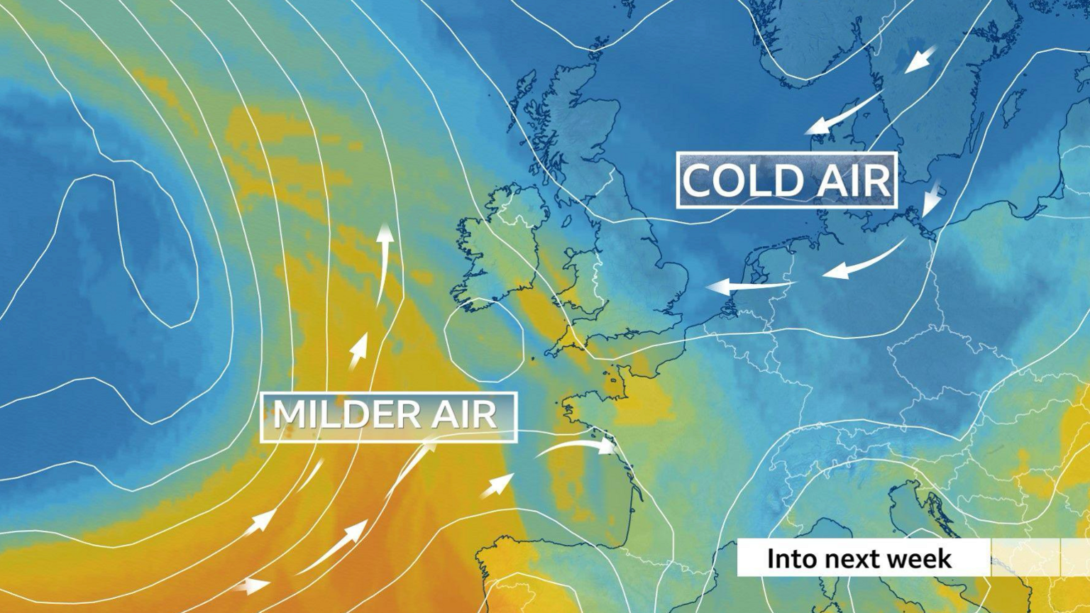
While Storm Ingrid will affect south-western parts of England, for the rest of the UK, we will start to see a brisk south-east to easterly wind.
Drawing in colder air from north-east Europe, temperatures will start to drop over the weekend and next week with a cold snap.
By Monday, temperatures will fall to 4 to 6C below the average for the end of January.
The easterly wind will also likely bring occasional wintry showers, with snow for some parts of the UK.
Where exactly, and how much snow, is not yet certain, but wintry hazards are likely.
-
UK weather warnings: What you need to know
-
2 hours ago
-
-
Weather for the week ahead
-
17 hours ago
-
Get in touch
Do you live in an affected area? Get in touch.


