

This post was originally published on this site.
Zahra Fatima & Cachella Smithand
Chris Fawkes,Lead weather presenter

 Getty Images
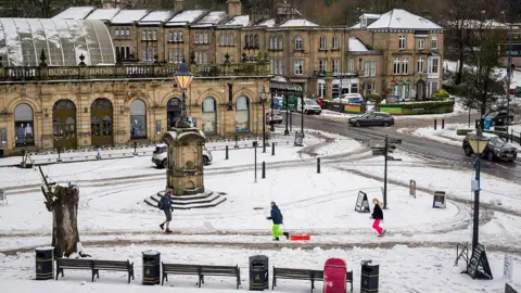
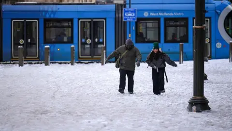
The UK is bracing for widespread ice and freezing temperatures on Saturday as tens of thousands of people remain without power.
Storm Goretti has brought heavy snow, ice and strong winds to the UK with more severe weather forecast.
Yellow weather warnings for snow and ice covering most of the country are in place until Saturday afternoon, while Scotland and northern England face a yellow warning on Sunday.
More than 34,000 premises are still without electricity in the South West and thousands more across the Midlands and Wales. The National Grid said it was working “tirelessly” to fix the issue and had restored power to almost 170,000 properties.
It said approximately 2,000 premises in the West Midlands, more than 1,000 in the East Midlands and 130 in Wales were among those still affected.
Meanwhile, the MP for St Austell and Newquay, Noah Law, said in a post on Facebook that properties “across mid Cornwall” were expected to face “electricity issues” until Sunday.
Cornwall Council said the storm had been “one of the most severe storms” the county had experienced “in living memory” with crews working around the clock to clear fallen trees and carry out emergency repairs.
 Tia White
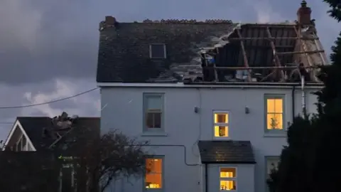
One resident told BBC Newsbeat the storm had blown the roof and chimney off her family home on Thursday night.
Tia White, 17, lives in St Buryan, near Lands End.
“We looked in the conservatory and the chimney had fallen off the top of the house onto the roof of the conservatory and smashed through,” she said.
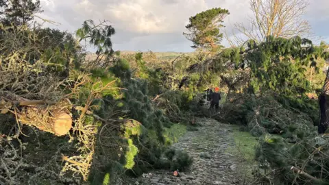
St Michael’s Mount, an island near Penzance, Cornwall, lost approximately 80% of the island’s trees on Thursday night.
 Darren Little/PA
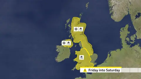
Where are the weather warnings?
Yellow weather warnings for snow and ice, issued by the Met Office, are in place for the following areas:
- Scotland, the North of England, East Midlands, Yorkshire and Humber (snow and ice) – 12:00 Friday to 15:00 Saturday
- Midlands, London and South East England, East of England, North West and South West England, Wales and Yorkshire and Humber (ice)- 12:00 Friday to 12:00 Saturday
- Northern Ireland (snow and ice) – 17:00 Friday to 11:00 Saturday
- Scotland, Midlands, Yorkshire and Humber and North of England (snow and ice) – 02:00 Sunday to 15:00 Sunday
An earlier amber warning for snow, which covered much of the West Midlands, Wales, Gloucestershire and Yorkshire, ended on Friday morning – while a rare red warning for “severe wind” in parts of south west England had been in place late on Thursday.
Disruption to roads, flights and rail services
Tens of flights departing Heathrow on Friday morning were cancelled with the majority believed to be short-haul flights. According to the airport’s departure boards there were fewer cancellations in the afternoon and into the evening.
On Friday morning, Birmingham Airport reopened its runway “on a reduced basis” after suspending overnight operations due to heavy snow, and the East Midlands Airport also reopened its runway following a temporary closure.
 Getty Images
Rail passengers have also been urged to check their journeys ahead of travelling as National Rail said services could be affected until Sunday.
A number of operators were impacted by the weather on Friday including West Midlands Railway which told customers not to travel and East Midlands Railway which did not run services between Manchester Piccadilly and Sheffield.
On the roads, experts have urged drivers to drive with caution due to the icy roads, with the AA adding that wintry conditions could “reduce visibility in seconds”. Traffic Scotland has issued a number of yellow weather alerts which remain in place overnight.
Dozens of schools in the Midlands, Cornwall and Wales were closed on Friday. While in Scotland, hundreds of schools remained shut after a week of severe snow – meaning many students are yet to return from the Christmas break.
What is the weather forecast for the weekend?
Widespread ice is forecast to develop on Friday night as temperatures plunge below freezing.
Showers will continue with some snow for Scotland and the hills of north-east England, with a few centimetres accumulating overnight for some.
On Saturday there will be more sunshine and some showers – with some snow forecast in Scotland and in the hills of north-east England.
It will be another cold day with temperatures well below average.
Milder weather is expected to start pushing into the UK on Sunday, with low pressure bringing wet and windy weather.
There may be a spell of snow but in most places this won’t last long before it turns back to rain. The snow will last longest in north-eastern areas, and especially over high ground, threatening some disruption for a time.
By Sunday afternoon temperatures in the south west are expected to reach 12C (53.6F), but it will stay quite cold in the north east. The milder weather will move across the whole of the UK by Monday.
Flood warnings have also been issued – with 12 in place in England setting out that flooding is expected, and an additional 118 flood alerts saying that flooding is possible.
Natural Resources Wales has two flood alerts in place.
An avalanche warning for Yr Wyddfa, also known as Snowdon, was issued in Wales on Thursday.
Two emergency alerts were sent out to the mobile phones of about 500,000 people in Cornwall and Isles of Scilly to warn them as a rare red warning for “exceptionally strong wind”, which expired at 23:00 on Thursday night.
According to the Met Office, gusts of 99mph were reached at St Mary’s Airport on the Isles of Scilly.
One Guernsey resident told the BBC he was taken to A&E on Thursday night having been injured by flying debris.
The local government had declared the storm a major incident, warning of strong winds on the island.
“The flat roof came through my window straight at me, it was terrifying really,” he said.
 Reuters
Over the past week, an Arctic blast has brought temperatures of between 4 and 10C below the January average.
The UK Health Security Agency (UKHSA) has issued amber cold health alerts for England, which will run until midday Monday.
Low temperatures have already triggered the government’s cold weather payments across at least 697 postcodes in England, Wales and Northern Ireland. It means that more than one million households will receive money.


